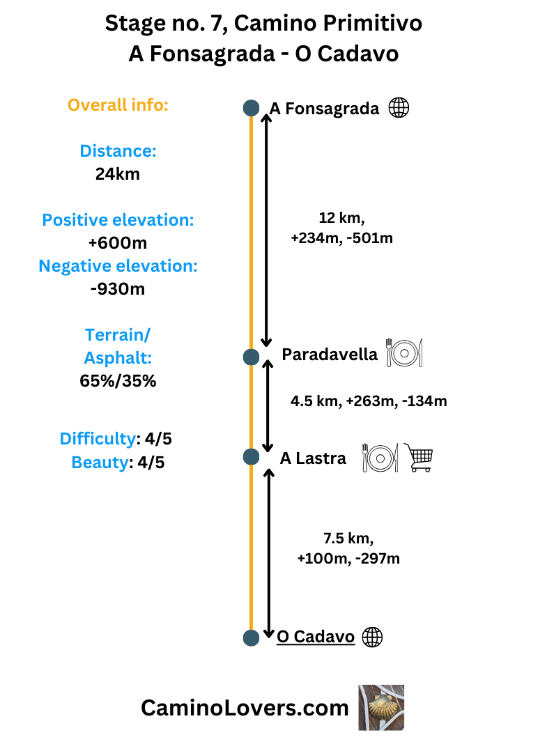
Basic Details
- Starting point: A Fonsagrada, the first biggest Galician town on Camino Primitivo (after you cross the border from the province of Asturias–no worries, no passport or visa needed :)), with roughly 5,000 inhabitants, four pilgrim hostels, and all services.
- Ending point: A small town of O Cadavo, which lives basically from two things–animal husbandry and Camino de Santiago. It has roughly 1,200 inhabitants (decreasing each year, sadly people are leaving Galicia), three pilgrim hostels, and all services a pilgrim may seek on his journey (think shop, pharmacy, bars, and so on).
- Availability of alternative routes: Yes, there is an alternative route, signposted with Camino signs and yellow arrows, heading north from Fonsagrada instead of West, and reconnecting with the official Camino some 12 kilometers later. I have mapped it for you here: link. A few things to help you decide whether you should take this alternative route, or follow the official Camino instead:
- The alternative route is 4 kilometers longer, and adds 150 extra vertical meters to your daily climb.
- This alternative route is more quiet, takes you further away from the relatively busy provincial road LU-530, but surprisingly actually has more paved road walking than the official Camino (which takes you more on unpaved roads and trails, though you always stay close to the provincial road with relatively busy traffic).
- Except of nice Galician countryside (a bit more authentic than on the official Camino) that you can observe along the alternative route, the biggest highlight is the small hamlet of Chao, with a castle called “Castelo de Proba de Buron“. This is now a private castle, and you cannot go inside, but it dates back to 15th century and it is a nice place to see, if you’re into history and such things. You can check the location and some photos on Google maps here. Hence that’s some information to the alternative route, and it is up to you to decide whether you take it (and add 4 extra km to your walk), or opt for the official route…
- Distance: Official Camino route: 24 km (download GPS here). Alternative route: 28km (download GPS here).
- Link to online map: Official camino route: here. Alternative route: here.
- Elevation difference: Official Camino route: +600m, –930m. Alternative camino route: + 730m, -1,050m.
- Difficulty score: Official Camino: 4/5. Alternative route: 4/5.
- Beauty score: Official Camino: 4/5. Alternative route: 4/5.
- Terrain/asphalt: Official Camino: 65%/35%. Alternative route: 55%/45%. The number can be a bit misleading here, when it comes to your idea about the stage. While it is true that you will walk two thirds of time on unpaved roads (which is great and not that common for Camino in general), and while some sections are really nice nature wise, for the entire duration of the day you won’t get further than 1 km aerial distance from the provincial road LU-530, actually at times walking very close to it (on the official camino). What I try to say here is that this stage isn’t any walk in the wilderness :). But it isn’t bad either, as you will see on the pictures in the gallery…
- Next stage: Camino Primitivo, Stage no. 8, O Cadavo – Lugo.
- Previous stage: Camino Primitivo, stage no. 6, Grandas de Salime – A Fonsagrada.
Elevation profiles for the route
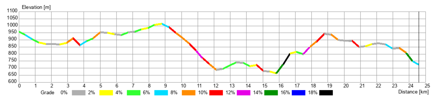 – Official Camino route, quite eventful to be honest, with steep and long descent from km 9 to km 12 (descending over 300 meters on 3 kilometers), and then a few shorter but steep climbs in the second part of the stage, with a gradient sometimes exceeding 18%. That’s why I gave the stage a difficulty score of 4/5, even though you won’t venture into some wilderness or technical terrain. It isn’t a easy one.
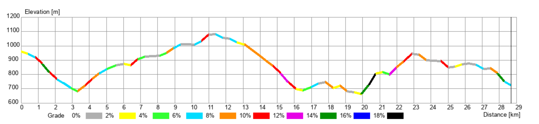 – An alternative route, as you can see it adds roughly 150 meters of extra elevation (150m up and 150m down), at the beginning, since you actually start with s descent. Then it climbs gradually and pleasantly until km no. 12 more or less, and from there on the chart is identical with the official route (the two routes connect here, at the old pilgrim hospital called Hospital Montouto). Hence you won’t avoid the two steep climbs in the second half of today’s stage by taking the alternative route.
Advanced info about the stage
- Trail marking: On the official Camino, the trail marking is really good, with plenty of stone markers (showing you both the right direction and the exact number of meters remaining to reach Santiago). What’s more, since you always stick close to the provincial road LU-530, and cross it on multiple occasions during the day, even if you accidentally take some wrong turn and reach the road, it is enough waling along it for a while and sure enough you’ll meet with the Camino again (when it will cross the road again). Speaking about the northern alternative route, I have never walked this one personally, and while I got some info from one pilgrim who followed this alternative, he did not remember how the trail marking was, since he always walked with the GPS and didn’t care much about the marks. Hence I cannot comment on this subject. To be on a safe side, you can always download our GPS for this alternative route (if you want to follow it instead of the official Camino), and check on your phone anytime you’re not sure whether or not you are on the right spot.
- Natural places worth seeing: It may be a bit unfair saying that, but from my experience there’s no special place worth a mention when it comes to natural beauty of this stage. That doesn’t mean it isn’t nice, just there aren’t any places standing out… What is nice and definitely not typical for most Caminos, almost all small town you’ll pass by have put together some rest area for pilgrims. This is typically a place with some benches, tables, sometimes some trees for a shade, sometimes a nice view, or a water fountain. Some of these places have nice views and good vibe, the problem is though that typically (and this is a common problem in Spain, not related only to the infrastructure of the Camino), the municipalities build these nice resting places, but then they do not maintain them, or only come a few times per year to cut the grass and that’s it… Obviously weather is rough in Galicia (and people sometimes too :)), and these wooden benches and tables and informational panels just cannot stand the test of time without some help and regular renovation, which they aren’t getting… Hence most of these places are relatively dilapidated, but nevertheless it isn’t a bad thing finding a bench to sit on and relax a bit during your day (even when the wood beneath you is slowly rotting :)).
- Historical, architectural, and culinary places worth seeing:
- The ancient pilgrim hospital of Montouto, right on the Camino, roughly 8 kilometers after Fonsagrada, exact location here. A nice spot, decently preserved, interesting remains of the ancient pilgrim hospital, which happens to be an archeological site too. Nice views and everything.
- The palace of Chao, Castelo de Pobra de Buron, on the alternative route (see the section “basic info” above, for more information on this route), 200 meters detour, exact location here. Worth seeing for people who are into castles and history, the entire hamlet of Chao has certain charm and stands out from the hamlets in the zone. Having said that, the castle is a private property (like almost every other castle in Spain that hasn’t been changed to Parador hotel :)), and you cannot get inside.
- Camping/bivouac options on this stage: Not a camping-friendly stage... You are always almost too close to the road, and almost all tempting side trails are gated or sign-posted as private property… Also the landscape is more open than it may seem based on the map. You can try your luck near this high-point, which is close to a relatively densely forested area and you can find a decent spot there. If you’re not too demanding and do not mind being seen, you can even try the recreational zone of Trabeiro, exactly here, which is pretty close to O Cadavo already. None of these two places are ideal for wild camping (far from that to be honest), but for an emergency situation they would do. There aren’t any organized camping places in the zone.
- Dog friendly score: 3/5. Average for the dog. Sometimes too much cattle, too open, sometimes nice trails. Sometimes too close to the road (or directly on it), sometimes not. Not many river or creek crossing but there are a few fountains along the way to replenish your bottle waters and let your beloved companion drink, or even cool itself in water. There is one pilgrim hostel in O Cadavo which accepts dogs, called Porta Santa, you can see the exact location on Google maps here. According to the information on their website you should let them know in advance that you are coming with a dog. So make sure to give them a call in advance.
- Special remarks: None.
My picks for accommodation on this stage
- Albergue O Pinieral, O Pinieral, km 3.5. Location and reviews on Google maps here. A modern complex of restaurant with a hotel and albergue on site. 44 beds in one room, but in fact the room is divided into many small places with walls, each having only 4beds–offering a bit of privacy. The kitchen is renowned for quality food with good prices, and the entire place is very well-managed and spotlessly clean. Quiet surroundings, great zones for relaxing both inside and outside of the place. 16-20 euro/night, check in from 1pm. Recommended way of making a reservation: booking.com, here.
- Albergue Pension Porta Santa, O Cadavo, km 24. Location and reviews on Google maps here. If I should pick one of the three albergues in O Cadavo, I would pick this one. Very clean with great facilities and well-equipped kitchen, nice attention to detail, beds in good condition. 16 places in 2 dorms, plus some private rooms should you seek more privacy for one night on the way. Prices start from 17 euro/night, check-in from noon already. Extremely pilgrim friendly. Recommended way of making a reservation: Either on Booking here, or WhatsApp, +34 679 828 540.

Pictures from the stage
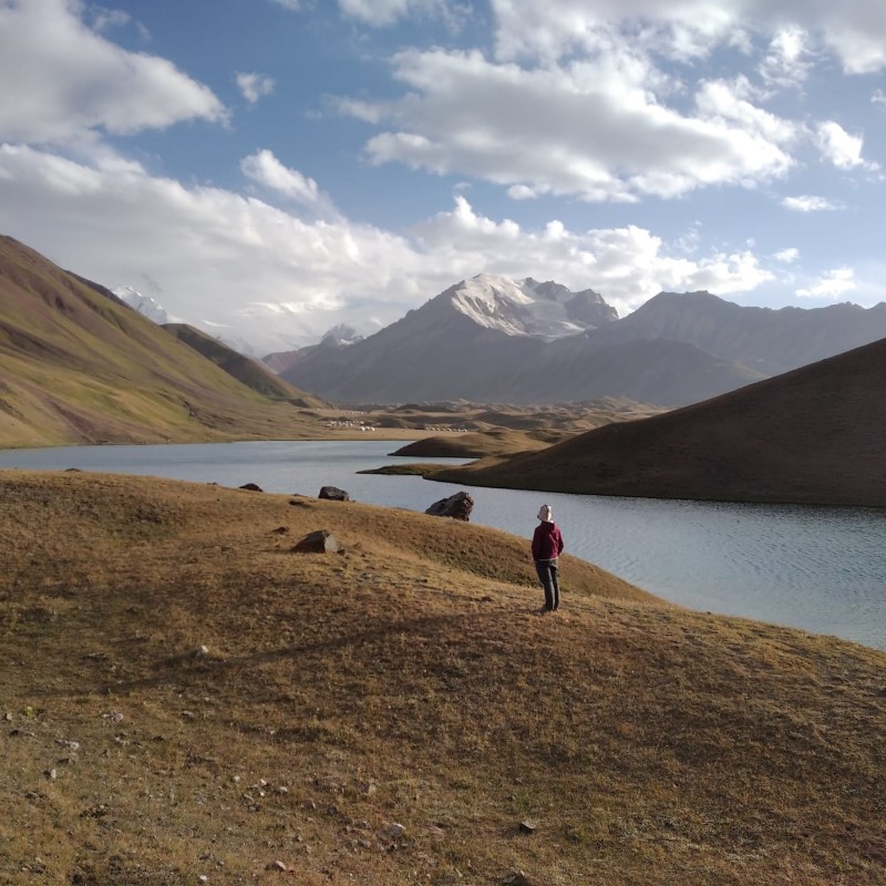
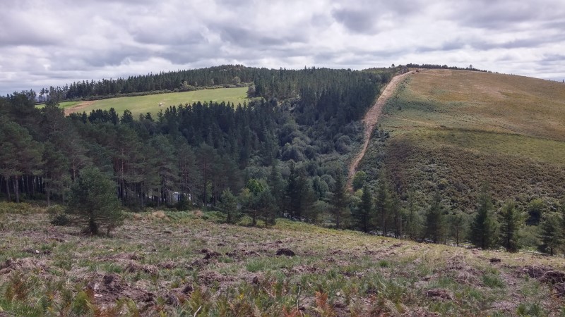
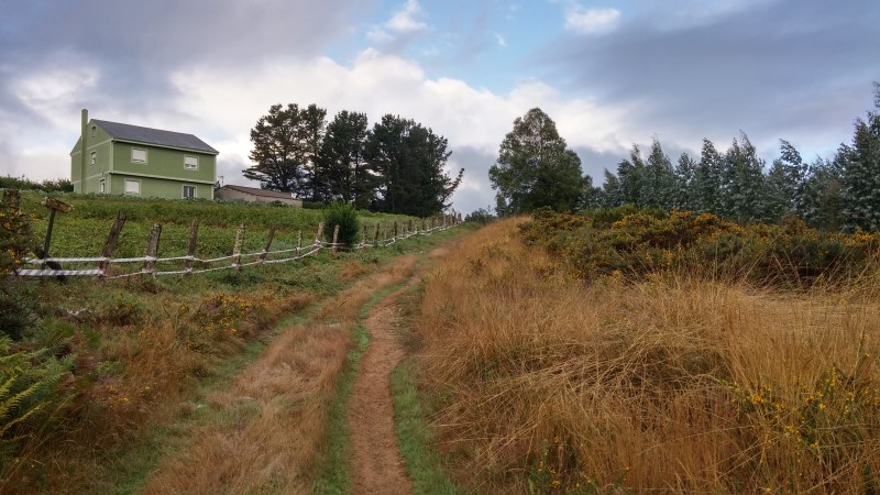 – A typical view on today’s walk. A quite characteristic landscape for this part of Galicia, in the altitudes approaching 1,000 meters above sea level.
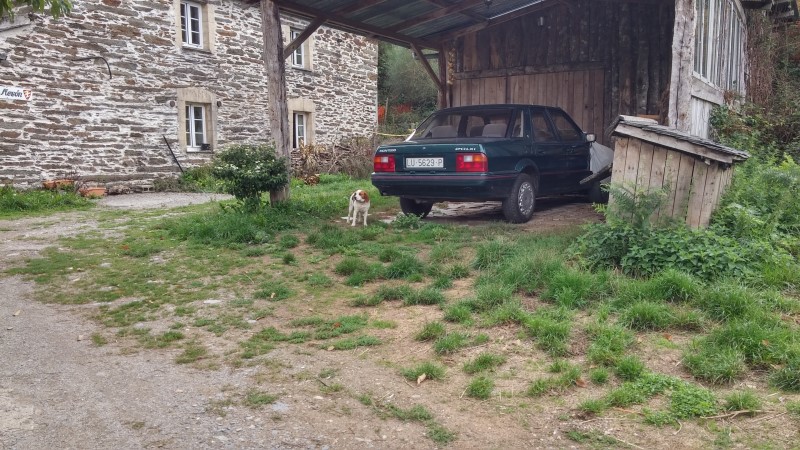 – Another nice doggie next to a car with a license plate following the old numbering system in Spain, abandoned in the year of 2,000. Hence the car on the picture already has some years (you aren’t obliged to change the license plate for a new one in Spain, you can keep the old one as long as you have the car).
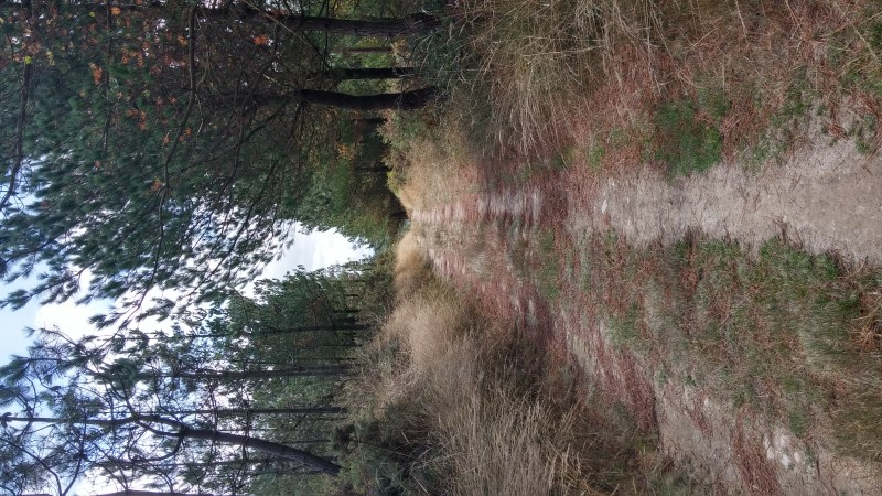 – A nice path surrounded by pine trees, again a typical sight for this altitudes of Galicia. You can also notice that the ground is quite dry, almost sandy. Who would expect that in a rainy Galicia? Well, the climate change is a real thing…
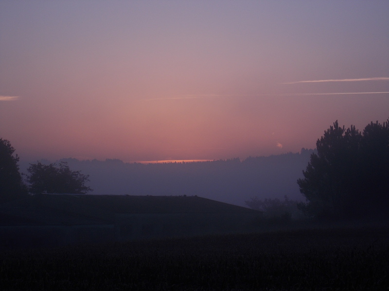
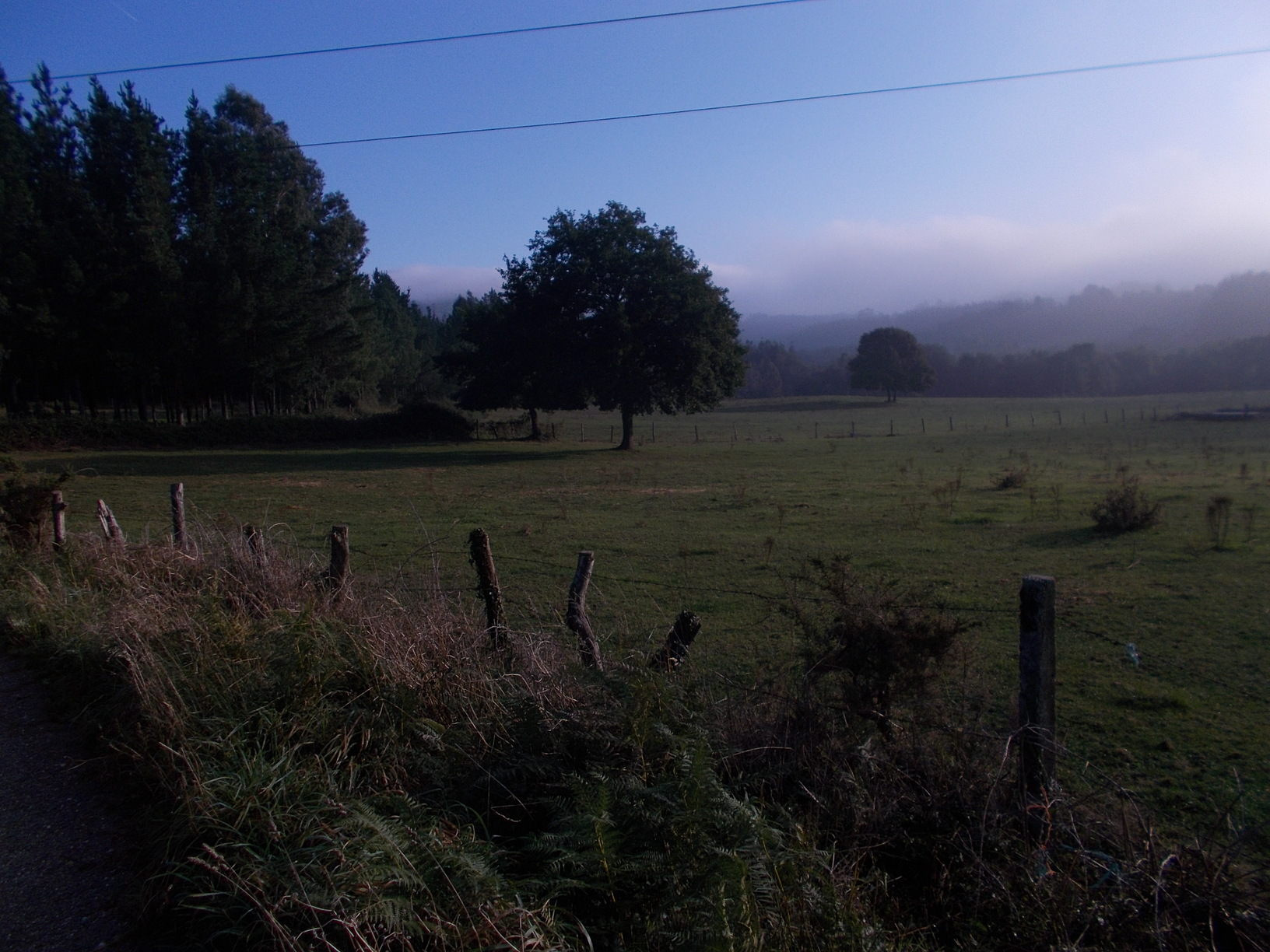
 – Random view from today’s walk.
 – Having an eye for a beauty and majesty of a random bush along the route is never a bad thing ;).
Few tips at the end
- Based on my pictures it may seem that you walk a lot in shade today, but the contrary is true. It is mostly an open landscape, and while the winds (typically strong on the Galician plateau) help with bearing heat, it is still a hard stage with some steep climbs. If you walk this in summer, I recommend starting early and trying to reach O Cadavo before 1pm. It isn’t an issue, since all 3 pilgrim hostels in O Cadavo open either at noon or at 1pm, so reaching the town early you can drop your backpack in one of them and head for a lunch :).
Next/Previous Stage
- Next stage: Camino Primitivo, Stage no. 8, O Cadavo – Lugo.
- Previous stage: Camino Primitivo, stage no. 6, Grandas de Salime – A Fonsagrada.

![Ultralight Packing List for Camino de Santiago [2025 Edition]](https://caminolovers.com/wp-content/uploads/2022/03/altra-shoes-640-x-480.jpg)