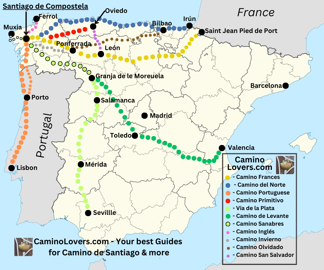
Technical details for all major Caminos in Spain
Explanations:
- Starting point: The typical starting point for the given Camino.
- Ending point: Typical ending point for the given Camino (not all Spanish Caminos end in Santiago de Compostela, though most of them do).
- Distance: Distance from starting to ending point of each Camino, in kilometers and in miles).
- Elevation gain: Cumulative elevation gain for each pilgrimage route, in meters and feet.
- Best period for walking: Recommended period for walking, based on weather, opening of the pilgrim shelters and other things.
- Recommended for: Some Caminos are better for history lovers, some for nature lovers. Some for those who seek company and talks, some for those who seek solitude. Some for people who seek relax and some for those who seek physical challenge. And while it is impossible to “label” the Caminos in this way, we at least try to give you an idea, to help you with your choice.
- Infrastructure for pilgrims: Score on a scale from 1 (virtually no infrastructure) to 5 (perfect infrastructure). Infrastructure means first and foremost pilgrim hostels, but also the availability of other accommodation, restaurants, supermarkets along the way, and so on.
- Approximate time to walk: We always give three estimates: First for those who walk fast and rush, second for a normal pace, and the last one for a relaxed way of doing the Camino. The time estimates take into consideration the technical difficulty of the terrain, the elevation gains and losses, the infrastructure for pilgrims, and other details.
- Crowded score: Score on a scale from 1 (virtually no pilgrims around or just very little of them) to 5 (super crowded, can be hard to get accommodation). The crowded score is always calculated in the high season for each given Camino, that means when most pilgrims do the given Camino.
- Alternative starting points: Alternative common starting points closer to Santiago, always with distance in kilometers and miles, then distance from Santiago de Compostela (meaning how many miles or kilometers you still need to walk from each alternative starting point).
1. Camino Frances – The French Camino
- Starting Point: St. Jean Pied de Port.
- Ending Point: Santiago de Compostela.
- Distance: 777 kilometers (482 miles).
- Total elevation gain: 12,543 meters (41,152 feet).
- Best time to walk: From April to November, but possible all year long.
- Recommended for: History, spirituality, variety of the terrain, meetings with pilgrims, best route for people who speak no Spanish.
- Infrastructure for pilgrims: 5/5.
- Approximate time to walk: Fast pace – 25 days; Normal pace – 32 days; Relaxed pace: 48 days.
- Crowded score: 5/5.
- Common starting point nearer to Santiago:
- Pamplona (700 km/ 435 miles from Santiago);
- Burgos (480 km/ 298 miles from Santiago);
- Leon (300 km / 186 miles from Santiago);
- Astorga (200 km / 124 miles from Santiago);
- Saria (114 km / 71 miles from Santiago).
- Best online & free guide for Camino Frances: Here.
Special Tip: Check our new tool, the Camino Progress Tracker, to see the distance and the exact elevation remaining to cover to Santiago, from ANY town on Camino Francs, Camino del Norte, Camino Primitivo, or Camino Portuguese.
2 . Camino del Norte – The northern way (Camino de la Costa)
- Starting Point: Irún.
- Ending Point: Santiago de Compostela.
- Distance: 829 kilometers (515 miles).
- Total elevation gain: 18,580 meters (60,958 feet).
- Best time to walk: From April to October
- Recommended for: Nature, beaches, holiday vibe in summer, history.
- Infrastructure for pilgrims: 4/5.
- Approximate time to walk: Fast pace – 28 days; Normal pace – 35 days; Relaxed pace: 50 days.
- Crowded score: 4/5.
- Common starting point nearer to Santiago:
- Bilbao (670 kilometers/ 416 miles from Santiago);
- Santander (560 kilometers / 348 miles from Santiago);
- Gijon (350 kilometers / 217 miles from Santiago);
- Ribadeo (205 kilometers / 127 miles from Santiago);
- Best online & free guide for Camino del Norte: Here.
3. Camino Portuguese (from Porto), coastal way
- Starting Point: Porto.
- Ending Point: Santiago de Compostela.
- Distance: 260 kilometers (161 miles).
- Total elevation gain: 2,767 meters (9,078 feet).
- Best time to walk: From April to September.
- Recommended for: Coast, physically less demanding camino, holiday vibe in summer.
- Infrastructure for pilgrims: 4/5.
- Approximate time to walk: Fast pace – 7 days; Normal pace – 10 days; Relaxed pace: 14 days.
- Crowded score: 5/5.
- Common starting point nearer to Santiago:
- A Ramallosa (110 km/ 68 miles from Santiago).
- Best online& free guide for Camino Portuguese de la Costa: Here.
4. Camino Portuguese, the Portugal way, inland variant
- Starting Point: Porto.
- Ending Point: Santiago de Compostela.
- Distance: 250 kilometers (155 miles).
- Total elevation gain: 2,698 meters (8,851 feet).
- Best time to walk: From April to October.
- Recommended for: Nature, spirituality, bit of history.
- Infrastructure for pilgrims: 4/5.
- Approximate time to walk: Fast pace – 8 days; Normal pace – 10 days; Relaxed pace: 15 days.
- Crowded score: 4/5.
- Common starting point nearer to Santiago:
- Tui (115 km/ 71 miles from Santiago).
5. Camino Primitivo, the “original” or “primitive” route
- Starting Point: Oviedo.
- Ending Point: Santiago de Compostela.
- Distance: 318 kilometers (197 miles).
- Total elevation gain: 8,185 meters (26,854 feet).
- Best time to walk: From May to mid October.
- Recommended for: Nature, smaller mountains, variety of terrain, history.
- Infrastructure for pilgrims: 5/5.
- Approximate time to walk: Fast pace – 9 days; Normal pace – 12 days; Relaxed pace: 16 days.
- Crowded score: 5/5.
- Common starting point nearer to Santiago:
- Lugo (105 kilometers / 65 miles from Santiago).
- Best online & free guide for Camino Primitivo: Here.
Special Tip: Check our new tool, the Camino Progress Tracker, to see the distance and the exact elevation remaining to cover to Santiago, from ANY town on Camino Francs, Camino del Norte, Camino Primitivo, or Camino Portuguese.
6. Via de la Plata – “The silver way” from Seville to Santiago
- Starting Point: Seville.
- Ending Point: Santiago de Compostela.
- Distance: 1000 kilometers (621 miles).
- Total elevation gain: 11,160 meters (36,610 feet).
- Best time to walk: April – May, September – October.
- Recommended for: History, self-reflection, great people, meeting with experienced pilgrims.
- Infrastructure for pilgrims: 3/5.
- Approximate time to walk: Fast pace – 30 days; Normal pace – 45 days; Relaxed pace: 65 days.
- Crowded score: 2/5.
- Common starting point nearer to Santiago:
- Mérida (790 kilometers / 490 miles from Santiago);
- Salamanca (500 kilometers / 310 miles from Santiago);
- Oursense (105 kilometers / 65 miles from Santiago).
7. Camino Ingles, “The English way”, the shortest from the St. James’s ways in Spain
- Starting Point: Ferrol
- Ending Point: Santiago de Compostela.
- Distance: 120 kilometers (74 miles).
- Total elevation gain: 2,018 meters (6,620 feet).
- Best time to walk: All year long.
- Recommended for: Rainy weather, easy walk, meeting experienced pilgrims.
- Infrastructure for pilgrims: 4/5.
- Approximate time to walk: Fast pace – 4 days; Normal pace – 5 days; Relaxed pace: 6 days.
- Crowded score: 2/5.
8. Camino Sanabres
- Starting Point: Granja de la Moreruela.
- Ending Point: Santiago de Compostela.
- Distance: 370 kilometers (230 miles).
- Total elevation gain: 6,163 meters (20,220 feet).
- Best time to walk: April – mid October.
- Recommended for: Nature, history.
- Infrastructure for pilgrims: 3/5.
- Approximate time to walk: Fast pace – 12 days; Normal pace – 15 days; Relaxed pace: 22 days.
- Crowded score: 2/5.
- Common starting point nearer to Santiago:
- Ourense (105 kilometers / 65 miles from Santiago).
9 . Camino de Levante – the longest way, crossing the Iberian Peninsula from South East to North West
- Starting Point: Valencia.
- Ending Point: Santiago de Compostela * connects to Via de La Plata in Zamora.
- Distance: 1110 kilometers (690 miles).
- Total elevation gain: 12,377 meters (40,606 feet).
- Best time to walk: mid March – May, September – October.
- Recommended for: History, variety, extreme physical challenge, solitude and reflection.
- Infrastructure for pilgrims: 1/5.
- Approximate time to walk: Fast pace – 35 days; Normal pace – 45 days; Relaxed pace: 65 days.
- Crowded score: 1/5.
- Common starting point nearer to Santiago:
- Albacete (890 kilometers/ 553 miles from Santiago);
- Toledo (645 kilometers/ 400 miles from Santiago);
- Avila (500 kilometers/ 310 miles from Santiago);
- Zamora * connection with Via de la Plata (350 kilometers/ 217 miles from Santiago).
10. Camino Fisterre & Muxia – Route to the end of the world and beyond
- Starting Point: Santiago de Compostela.
- Ending Point: Muxia (or the Cabo de Finisterre).
- Distance: 120 kilometers (75 miles).
- Total elevation gain: 2,121 meters (6,958 feet).
- Best time to walk: All year long.
- Recommended for: Nature, coast, sunsets, hippie vibe, rural Galicia.
- Infrastructure for pilgrims: 5/5.
- Approximate time to walk: Fast pace – 3 days; Normal pace – 4 days; Relaxed pce: 6 days.
- Crowded score: 4/5.
11. Camino Invierno – The “winter way”, or the less crowded alternative of Camino Frances from Ponferrada
- Starting Point: Ponferrada.
- Ending Point: Santiago de Compostela.
- Distance: 260 kilometers (161 miles).
- Total elevation gain: 4,891 meters (16,053 feet).
- Best time to walk: All year long.
- Recommended for: Nature, rural Galicia, river valleys.
- Infrastructure for pilgrims: 4/5.
- Approximate time to walk: Fast pace – 8 days; Normal pace – 10 days; Relaxed pace: 14 days.
- Crowded score: 2/5.
12. Camino de San Salvador – crossing the mountains from Leon to Oviedo
- Starting Point: Leon.
- Ending Point: Oviedo, from here you can continue walking towards Santiago de Compostela following the Camino Primitivo way.
- Distance: 120 kilometers (75 miles).
- Total elevation gain: 2,639 meters (8,660 feet).
- Best time to walk: June – September.
- Recommended for: High mountains, nature, physical challenge.
- Infrastructure for pilgrims: 3/5.
- Approximate time to walk: Fast pace – 4 days; Normal pace – 5 days; Relaxed pace: 7 days.
- Crowded score: 3/5.
13. Camino Olvidado – The forgotten way
- Starting Point: Bilbao.
- Ending Point: Villafranca del Bierzo (here it connects to Camino Frances, the French way).
- Distance: 530 kilometers (329 miles).
- Total elevation gain: 7,604 meters (24,984 feet) * the data are for the easiest version of Olvidado, if you follow the mountain alternatives (the most beautiful part of the way) you need to add roughly another 2,000 meters (or 6,500 feet) of elevation gain.
- Best time to walk: April – May, September – October.
- Recommended for: Nature, solitude, self-reflection, physical challenge.
- Infrastructure for pilgrims: 1/5.
- Approximate time to walk: Fast pace – 16 days; Normal pace – 21 days; Relaxed pace: 28 days.
- Crowded score: 1/5.
- Best online & free guide for Camino Olvidado: Here.
* If you need data for any other Camino route in Spain, such as distance or cumulative elevation gain, do not hesitate to contact us. Thank you! You can also check our new tool, the Camino Progress Tracker, to see the distance and the exact elevation remaining to cover to Santiago, from ANY town on Camino Francs, Camino del Norte, Camino Primitivo, or Camino Portuguese.
May also interest you:


![Ultralight Packing List for Camino de Santiago [2026 Edition]](https://caminolovers.com/wp-content/uploads/2022/03/altra-shoes-640-x-480.jpg)