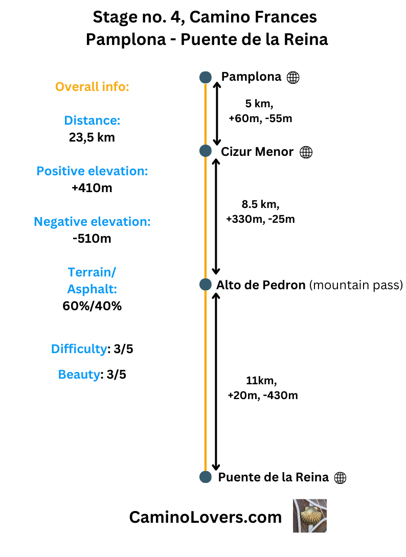
Basic Information
- Starting Point: Pamplona, Spain – The capital of Navarre, famous for its historic old town, Gothic cathedral, and the Running of the Bulls festival. Many pilgrim albergues, all services, often overcrowded with tourists.
- Ending Point: Puente la Reina, Spain – A charming town known for its iconic medieval bridge, where the Camino Francés and Camino Aragonés routes merge. Roughly 2,900 inhabitants, six pilgrim albergues, restaurants, shops, pharmacy, simply all facilities for pilgrims.
- Availability of an alternative route: Yes, recommended only for cyclists, or in a bad weather for people who don’t like steep sections, since it avoids the slippery steep downhill section from Alto de Pedron (more on the route in the text below).
- Distance: Official camino route: 24km (download GPS here). Alternative route: 25 km (download GPS here).
- Online Map: Official camino route: map. Alternative camino route: map.
- Elevation Difference: Official Camino: +410 m ascent, -510 m descent; Alternative route: +380 m ascent, – 480 m descent.
- Difficulty Score: 3/5 for both routes.
- Beauty Score: 3/5 for official camino, 2/5 for alternative route. The route passes through nice vineyards and farmlands, with the high point of today’s walk definitely the Alto de Pedron, with beautiful views in all directions.
- Terrain/Asphalt Walking Ratio: Official route: 60% trails, 40% asphalt/paved roads, or on side of a road. Alternative route: 40% trails, 60% asphalt.
- Next stage: Camino Frances Stage no. 5, Puente de la Reina – Estella.
- Previous stage: Camino Frances, Stage no. 3, Zubiri – Pamplona.
Elevation profile for the route

– Official camino, as you can see you do most of your climbing from km 9 to km 13. The steepest gradient (sometimes passing 20%) is on a descent from Alto de Pedron though (km 14). This section can be tricky for people with bad knees or little hiking experience, and it is the most common reason why some people opt for an alternative route.
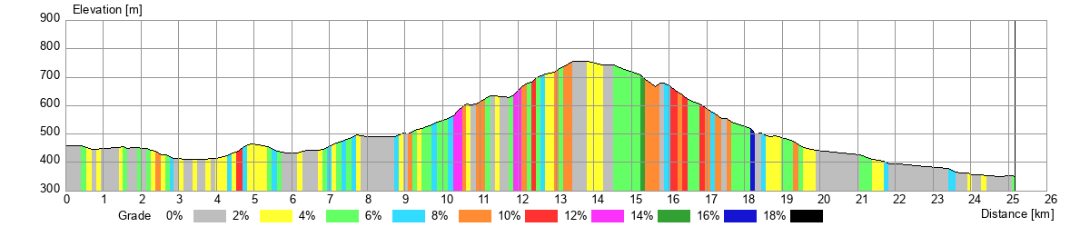
– Alternative camino, identical until km 11, then it changes, avoiding the steep muddy (in rainy weather) descent from Alto de Pedron, and opting rather for a more conservative descent on a paved route. It also avoids some small hills in the second half of the stage when compared to the official camino. The price you pay, however, is more asphalt/road walking, sometimes close to the A12 highway.
Advanced Info About the Stage
- Trail Marking: All good, with open landscapes and trail with pilgrims in front of you always visible. One lesser know camino called Camino Aragones will join us today, merging with the French way before Puente de La Reina. Since the routes merge here, you have no way of walking in the wrong direction. But I still wanted to mention this to make sure seeing some pilgrims walking from a totally different direction won’t confuse you.
- Alternative Route Info: The main purpose of this alternative route is to avoid the steep downhill from Alto de Pedron, which can get muddy and technical in certain weather conditions, and can poses some problems for hikers with little experience and obviously for people doing the Camino on bike. The detour was marked when I was there the last time, however, even if it is not, it i very easy to follow it. Once you reach the pass, just follow the asphalt road, heading right. You will pass a rest area and a parking place, and eventually following this road descend to the other side of the ridge. Passing through a village of Legarda, you follow the same main road always, until you connect with the official camino route before Puente de la Reina.
- Natural Places Worth Seeing:
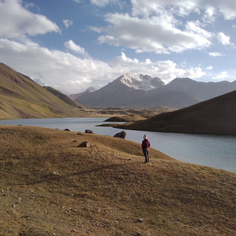
- Alto del Pedron: An iconic mountain pass with panoramic views and the famous sculpture of pilgrims (see pictures below). Legend say that all your sins are forgotten once you climb here as a pilgrim on your way to Santiago, and have an honest desire to repent and live better from now on. That’s the harder part than the climb I guess :). Location on Google maps here. Notice that the pilgrims are actually depicted with donkeys, which was historically quite a popular way to do the camino, and some people attempt it even today.
- The green downhill from Alto de Pedron: While steep and sometimes technical, the downhill from Alto de Pedron is beautiful with a variety of trees with vibrant green colors. You should enjoy this scenery, because it will take some time from now on until we pass through a really green spot on this Camino again…
- Historical, Architectural, and Culinary Places Worth Seeing:
- Church of St. Mary of Eunate, A stunning 12th century Romanesque church with octagonal design , location and reviews on Google maps here. A short detour from the Camino, clearly signposted (you’ll connect back to the way later on). Unique design, entrance fee, pilgrims get a discount (and a nice stamp to their pilgrim passports :)). Definitely worth the detour.
- Puente de los Peregrinos (Puente la Reina): Medieval bridge that marks the end of the stage. Location on Google maps here. What more to say? This Camino is just ideal for people who love old bridges. But this one is really nice, not only for the architecture, but also the locations and the views one has nearby.
- Camping/Bivouac Options on the Stage: There is one organized camping place near Puente la Reina, called Camping Real. Location and reviews on Google maps here. It actually has also dormitory with bunk beds, and serves as an albergue, but you can also pitch your tent for 10 euro/night in the garden. Rumors are that nowadays they host refugees there and the place isn’t available for camping or pilgrims anymore, so you better call in advance to check out the actual situation. Phone number: +34660701246. When it comes to wild camping/bivouac, the only good option is on the ridge close to Alto de Pedron. Having said that, this works only if you do not mind the sound and constant buzz of the wind turbines, which are present and loud everywhere on the ridge.
- Dog-Friendly Score: 3/5. The trails are mostly open, so start early with your beloved dog to avoid the afternoon heat. Luckily there are some spots and even shorter sections with trees and enough shade. You should certainly take the official route with the dog, the alternative one is all on the road from Alto de Pedron onward. The only albergue in Puente la Reina accepting dogs is called Albergue Jakue. It is a hotel that has some sections for pilgrims, and nice spaces for dogs. Location on Google maps here, I recommend calling in advance and informing them that you plan to arrive with a dog.
- Special Remarks: None.
My picks for accommodation on this stage
- Albergue de Peregrinos de Cizur Menor (km 5): Located just outside Pamplona, this small albergue for almost a symbolic price of 7euro/night, basic breakfast included, is an oasis of peace for anyone who wants to avoid the buzz of a bi city, and simply walk through Pamplona. Has 27 beds and almost never fills up, so you’ll be all right simply walking here anytime between noon and 10pm (it is an option also when you want to stay in Pamplona but eventually do not find a free bed in town). Basic but clean, location on Google maps and reviews here.
- Albergue Estrella Guia, Puente de la Reina (km 23.5): First of all, it is hard picking one best albergue in Puente de la Reina, since each has some problems… Either very old installations, or price way too high for a pilgrim, or little to no pilgrimage spirit. But if I have to recommend one, I will go with Estrella Guia. Location and reviews on Google maps here. The host Natalia is very nice, offers a service of massage (for extra cost $$$), and I also like the location close to the river. Price 23 euro for a bunk bed, breakfast is another 8,50 euro… Check-in from 1pm, accepts reservations, +34 622 262 431, you can book it for the best price on Booking.com here.

Pictures from the stage
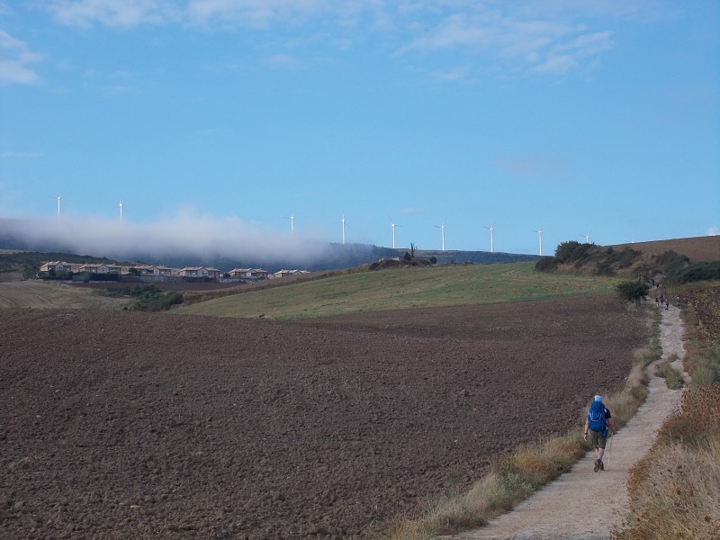 – Early stages of today’s walk, with the ridge of Alto de Pedron already in sight (the controversial wind turbines)
 – Pilgrims climbing Alto de Pedron, with the city of Pamplona in the background.
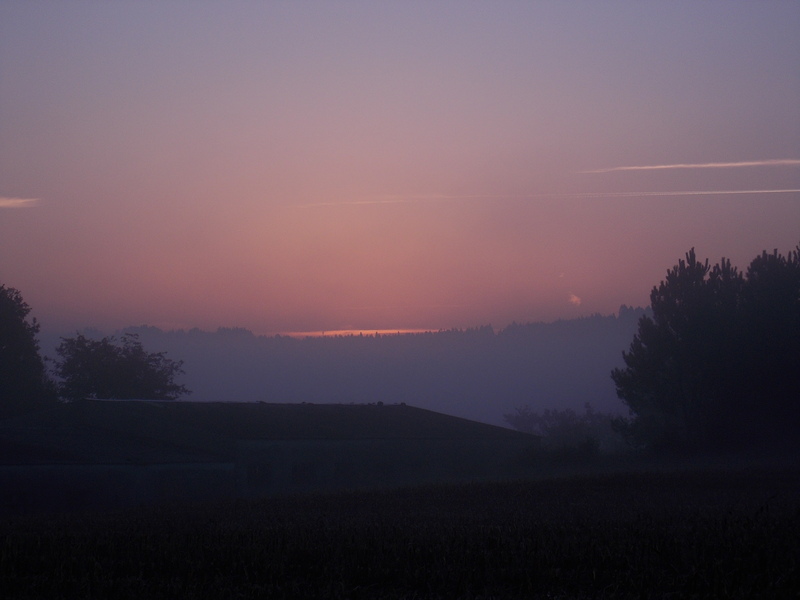
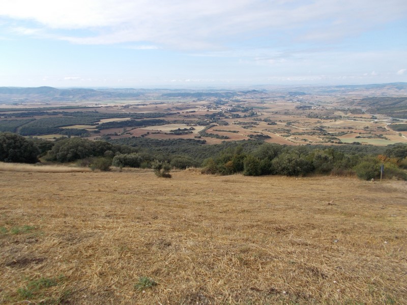 – Already on the top, with views to the other side. A bit too dry, isn’t it? But it has its charm nevertheless.
 – The ridge with wind-turbines, stretching several kilometers in both directions.
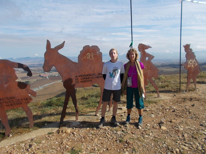 – With American pilgrim near the famous metal statues on Alto de Pedron. Were all my sins really forgotten here? That’s hard to say ;).
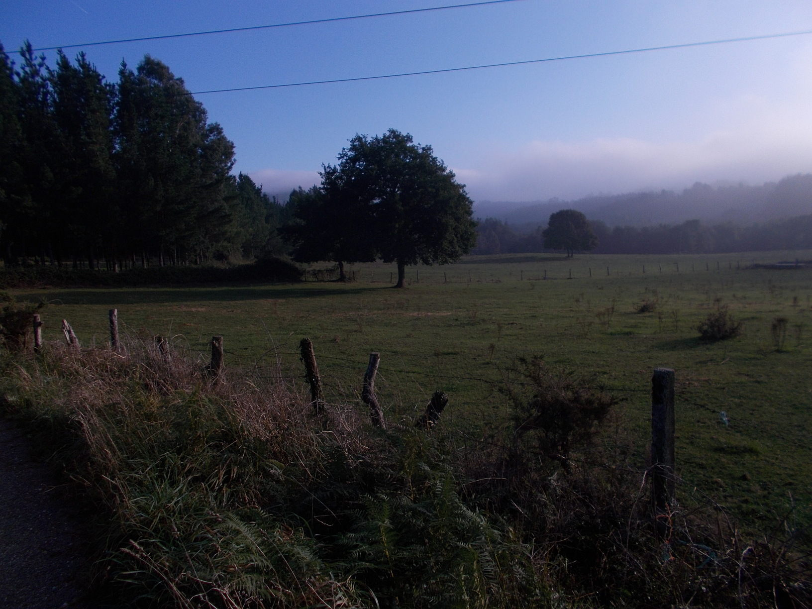
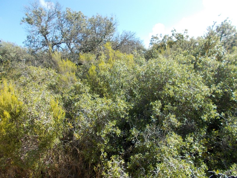 – Some surprisingly green vegetation on the other side of Alto de Pedron. We should enjoy it while it lasts, because we’re entering a rather dry section of the camino…
Few Tips at the End
- Explore a bit more the ridge of Pedron. Once you reach Alto de Pedron, you cross paths with GR220, a over 100km loop trail in Navarre. It is signposted with red and white marks. I do not suggest leaving the Camino and walking this trail, but if you like to enjoy a bit more solitude, you can turn left here, following the GR220 to the highest point of the ridge, which is about 2.5 km away from the Camino. Or you can walk just a bit here. In any case, you’ll have some nice views, lot of wind turbines, and there is even a small chapel if you reach the very top of the ridge ;).
- If you sleep for the previous night after Pamplona, for example in Zariquiegui, in albergue San Andres, you may consider starting at dawn and watching the sunrise from Alto de Pedron. Reaching alto de Pedron before sunrise is unrealistic from Pamplona or even Cizur Menor, but it is only 2.3 km from Zariquiegui (all climbing), which can be done in 30 minutes to one hour, depending on how fast you are on uphills :). Anyway, the sunrise from here is beautiful, and worth the early wake up, should you spend the night in Zariquiegui. Just an idea for people who love sunrises just as I do :).
Next/Previous Stage
- Next stage: Camino Frances Stage no. 5, Puente de la Reina – Estella.
- Previous stage: Camino Frances, Stage no. 3, Zubiri – Pamplona.

![Ultralight Packing List for Camino de Santiago [2025 Edition]](https://caminolovers.com/wp-content/uploads/2022/03/altra-shoes-640-x-480.jpg)