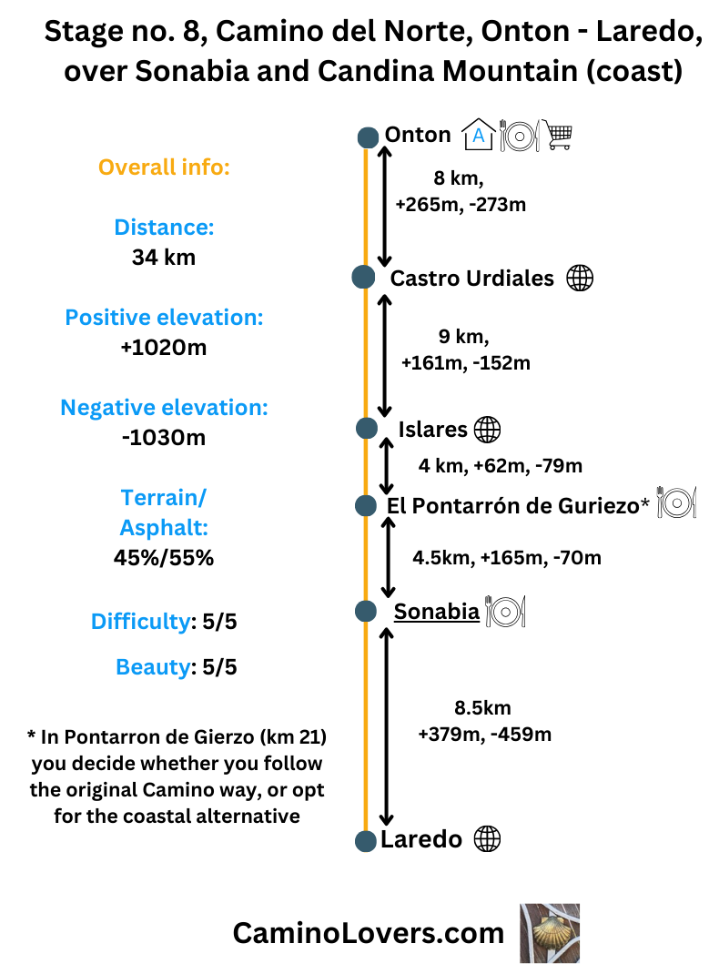
 – Illustration map of the way, detail on the alternative route, and where it connects back to the official Camino.
Basic Details
- Starting point: Albergue de Peregrinos Onton
- Ending point: Center of Laredo.
- Link to online map: here.
- Availability of alternative routes: This is an alternative route, and in my unbiased opinion, one of the top 3 most beautiful parts of the entire Camino del Norte. It goes through a spectacular natural reserve at the edge of the ocean. Pristine beaches, cliffs, a green mountain right at the ocean, and a short but steep part of the path you’ll remember all the way to Santiago :). Basically until a roundabout in a small place called Nocina, you follow the official Camino route. Than on this roundabout you leave it, walk the spectacular alternative route, and connect back to the Camino just close to the beach of San Julian (near the village of Liendo). You will find a more extensive description of the route below, in the “advanced info” section.
- Distance: 34km (download GPS here).
- Elevation difference: +1020m, -1030m
- Difficulty score: 5/5
- Beauty score: 5/5 (No doubt one of the most beautiful stretches on the entire Camino del Norte)
- Terrain/asphalt: 45%/55% .
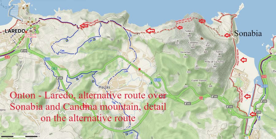
Elevation profile for the route
 – elevation profile of the way. Notice the steep gradient after kilometer 26. That’s the steep climb (and an unforgettable descent) of the Candina mountain, the natural marvel right at the edge of the ocean.
Advanced info about the stage
- Trail marking: Now we’re in Cantabria already, and to be honest, it is the province with the worst trail marking on the entire Camino del Norte. That’s why I recommend you downloading the GPS for this stage, and also check regularly on your mobile phone that you’re still on the way. The trail over the Candina mountain is marked with black arrows and dots (you can see one such in a gallery below). The trail is obvious, with an exception of two places.
- No. 1. After following the trail from Sonabia for about 1.2 kilometers, you have to turn sharp left and climb sharply up, to reach the high plato in the massive of the mountain. In my experience, about 50% of all people doing this trail (including both pilgrims and non-pilgrims) make a mistake here, continuing straight. Than what happens is that they reach cliffs where it is impossible to continue. These are the people who go back to Sonabia and return to the official camino, and later claim the way is dangerous and people should not go there. But in fact the dangerous part they encountered isn’t on a trail at all… They simply missed the sharp turn left and that’s the reason why they reached impassable cliffs.
- No. 2. About 500 meters after crossing the “Paso de Presa” (see picture in the gallery below), you’ll reach a point where trail suddenly splits into different directions. But you can see here already the beach of San Julian and Laredo in the distance, and have to follow the trail that goes sharply down, in that direction. The other options are either going up (to the top of the mountain) or more or less follow a level ground, and that’s not the direction to go. You have to go down, including one short section (1 meter) of super easy climbing At the end of the day, you can always help yourself with GPS I got for you, or with some good mapping application for the Camino.
- Natural places worth seeing: The entire trail over the Candina mountain is spectacular. Pristine beaches with little tourism, cliffs, rocks, trees, a nice trail on the edge of the ocean, you name it. One video is perhaps better than a thousand words:
- Historical, architectural, and culinary places worth seeing: For the information on historical and architectural places worth seeing, check our article for the official camino route for Onton – Laredo.
- Camping/bivouac options on this stage:The entire plateau of the Candina mountain (after you pass the Paso de Presa) is great for camping, views, and everything. Just make sure to have provisions with you, because obviously it is a mountain and you won’t find either water or food there. The terrain is rather rocky and not super flat, but with eye for good camping spots you can find a few of them on this 500 meters long stretch. I camped here once myself, so it is definitely not an issue, and nobody will disturb you. An approximate GPS location of the camping spots is here. It is also possible to camp close to the Ermita de San Julian, for example on an amazing viewpoint of the beach of San Julian (exactly here), but in contrary to the Candina mountain, some people may venture here in the late afternoon (it is quite a romantic spot so understandable that some couples may go there–if they know it), so it is highly recommended to pitch your tent when the sun is already getting down…
- Dog friendly score: 4/5. Generally a very decent stage for dogs, with several refreshing points, and a big chunk of the route following trails and a type of terrain dogs enjoy walking over. Just make sure to take enough water for both yourself and the dog when crossing the Candina mountain. The only minus is the final point–Laredo, which is a kind of bigger ghost city, where finding dog-friendly accommodation is more than tricky. Hence with the dog, I strongly suggest you to camp before Laredo, and on the next day simply walk through the city and never look back :).
- Special remarks: Enjoy this stage to the fullest, since you won’t have any such beautiful stages on your entire way to Santiago. If you believe the saying that “it is the way that matters, and not the destination“, you should definitely take this alternative route, do it slowly and enjoy it.
Pictures from the stage
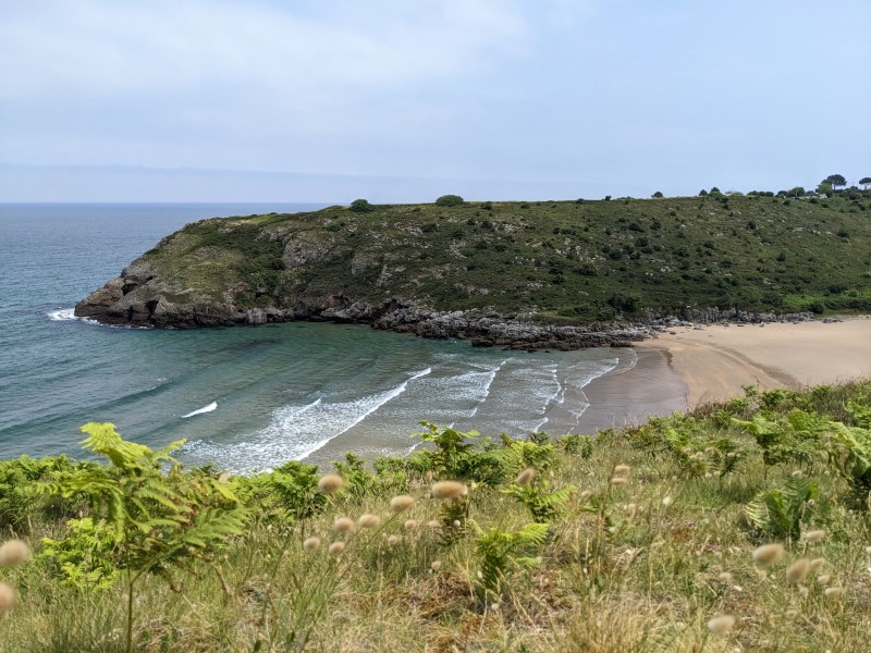 – Beach of Sonabia, a place where it is almost always sunny. The beach is “nudist-friendly”, and you will almost always find some naked guys walking there. However, it isn’t a strictly nudist beach, so you do not have to worry being there in your swimsuit, or a sweaty pilgrim t-shirt 🙂

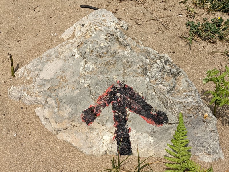 – The route to Liendo (or beach of San Juan) over the Candina mountain (the route we follow) is marked by black arrows and black dots on rocks. If you pay attention you won’t get lost, but I still recommend you getting the GPS for this route, because there are two or three points when the trail marking isn’t particularly obvious, and people with worse navigation skills can get lost.
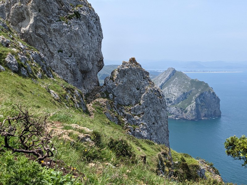
 – The trail, about 1 km up, in the distance you can see the beach of Sonabia, the natural reserve of Sonabia, and also the village of Sonabia.
 – “Paso de Presa“, one of the iconic points of this route. You have a rope to help you here, it isn’t really necessary, but helps if you happen to pass by on a windy day, or if the rocks are slippery.
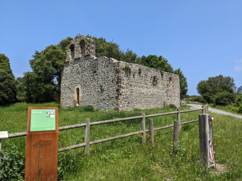 – Chapel of San Julian, a place where you will join the “official” camino route. Once you have reached this point, you do not have to be worried about getting lost or about encountering any other steep climb.
 – Beach of San Julian with wonderful natural surroundings.
 – Detail on a beach of San Julian. As you can see, it is a beautiful hot sunny day, and there isn’t really anyone on the beach… You can just dream of such a scenario on a typical tourist beach of the north coast of Spain.
Few tips at the end
- Make sure to take enough water for the crossing of the Candina mountain. Although not particularly long, it is typically a very sunny mountain, and you will sweat a lot on the steep climb (especially with the heavy backpack).
- Do not get discouraged by the signs on the road, signs that say that it is dangerous, not fitting for pilgrims, etc. The way is perfectly all right for any pilgrim in a decent shape (I’ve seen a fit lady in her 70ties following this route). It is just important not getting lost, and not being afraid of heights. As long as you follow the GPS, and pay attention to the black dots and arrows, you won’t get lost, and if you don’t get lost, the way isn’t dangerous in any means.
- Book your accommodation in Laredo in advance, so you have enough time to enjoy this unforgettable trail, without having to race for beds with other pilgrims.
Next/Previous Stage
- Next stage: Camino del Norte stage no. 9, Laredo – Guemes
- Previous stage: Camino del Norte, stage no. 7, Bilbao – Onton
- “Official” Camino route for this stage: Camino del Norte official, stage no. 8 – Onton – Laredo.

![Ultralight Packing List for Camino de Santiago [2025 Edition]](https://caminolovers.com/wp-content/uploads/2022/03/altra-shoes-640-x-480.jpg)